
Product summary
Below is a table of all products that can be applied to core imagery through a Datarock Core subscription. Click each product name to learn more about how they work.
|
Product |
Dependencies |
Visualised in Platform |
|---|---|---|
|
|
✅ |
|
|
Geotech Bundle |
|
|
|
ARD |
✅ |
|
|
ARD, RQD |
✅ |
|
|
ARD, RQD, Fractures |
✅ |
|
|
Advanced Geotech Bundle |
|
|
|
ARD, RQD, Fractures, JSA |
Coming soon |
|
| RQD Weighted Joint Density |
ARD, RQD, Fractures, JSA |
Coming soon |
|
ARD, RQD, Fractures, JSA |
Coming soon |
|
|
ARD |
✅ |
|
|
ARD, RQD, Fractures, JSA, WJD, GWI, JRC |
Coming soon |
|
|
Standalone products |
|
|
|
ARD |
Coming soon |
|
|
ARD, RQD, Fractures, JSA |
Coming soon |
|
|
ARD, RQD, Fractures, JSA |
Coming soon |
|
|
Bespoke products |
|
|
|
ARD |
Signature Search Only |
|
|
ARD |
Coming soon |
|
* included in every subscription
Analytics-Ready Data
This is used by every other product and is included with every Datarock Core subscription. It comprises image preparation and depth registration - minimum processes to analyse core imagery for any subsequent product.
Geotechnical Bundles
Geotech products are grouped into 2 bundles available through a Datarock Core subscription. These bundles have been created with product dependencies in mind, to ensure all products within a bundle can be delivered. The Geotech Bundle is included as the base product in all subscriptions, as many other products require data from this bundle.
Standalone products
These are single products available to add to any Datarock Core subscription.
Bespoke products
These are advanced classification and segmentation products that require assessment to ascertain technical feasibility. They analyse complex geological and geotechnical features including, but not limited to:
- veins
- lithology
- alteration
- individual minerals
- mineral textures
Bespoke products require an extended discussion with Datarock's technical team to understand the business problem, the quality of imagery, the presentation of the specific geological or geotechnical features in imagery, and the solution requirements. Only then can our team determine the appropriate model type and approach to use.
Product dependencies
In order for a product to be part of your subscription, it is necessary to acquire its dependencies as well. When you use a product on the Platform, it will automatically include and run any required dependencies. The table above also details the dependencies for each product.
Required metadata
Below is a summary of the required metadata for all Datarock Core products.
⚠️Please note: all products require core imagery to run.
📸Review our Minimum Imagery Requirements for products and our Core Photography Guidelines for best practice on taking analytics-ready drill core photos.
| Product | Required metadata | Useful metadata |
| Analytics-Ready Data | Core loss file | |
| Geotech Bundle | minimum 10 logged holes |
collar & survey files |
| Adv. Geotech Bundle | collar & survey files | |
| Dominant Colour | collar & survey files | |
| Discing Analysis | All available logging | collar & survey files |
| Fracture Orientation | collar & survey files, orientation lines, positive dip direction | |
| Bespoke products | collar & survey files, geology logs, geology class slides, |
Model types
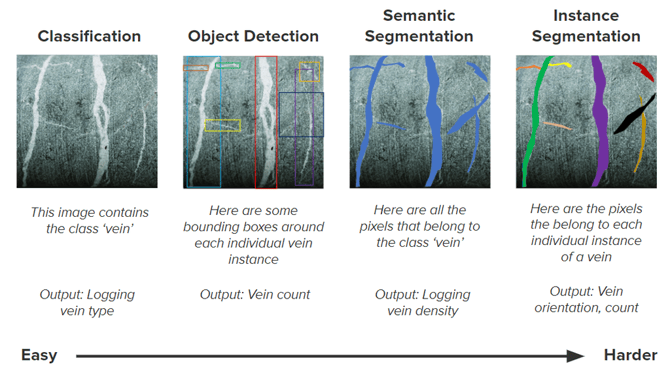
Below is an image illustrating the range of model types Datarock uses to develop products. It ranges from simple classification of an image, detection of objects within an image, the semantic segmentation of a single class, and instance segmentation of multiple classes) model.
Classification model sub-types
Classification models are applied at an image level; at Datarock we can scale image sizes to suit the different geological or geotechnical features that require identification and modelling.
This scale is ideally tailored to the downstream application of the solution, whether it's a lithology log that requires every metre along a drill hole to be assigned a rock type or a vein log identifying discrete intervals of a particular vein mineral or style.
To achieve this, Datarock has created two classification scales:
- Domain Search: classification model trained at a resolution more suitable for interpretation of large-scale geological features (e.g. lithology/rock type, alteration, weathering). Model training uses 1m interval row imagery data sourced from the Datarock Platform.
- Signature Search: classification model trained at a resolution more suitable for identifying fine geological features at the centimetre-scale (e.g. veins, breccia, minerals). Model training uses 5cm interval square or tile imagery data sourced from the Datarock Platform.
Whilst the overall workflow is unchanged between the two types of classification, the different resolutions allow for greater flexibility and accuracy in creating a product that best suits a customer's requirements and resolution of outputs.